Sunday 26 August 2012

Bath Road, Wells

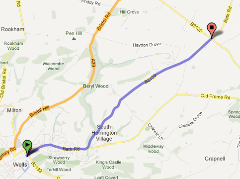
This route is the B3139 which goes north west out of Wells - worth mentioning as the A39 Bristol Hill route might be the way many of us would choose to use to get from Wells to Bath...

Start: Near Wells Cathedral at GR553459       Finish: Whitnell Corner cross roads  GR597487
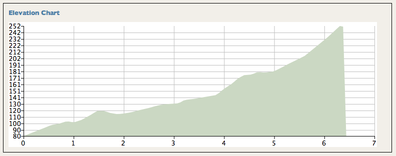
Height Gain: 180m   Horizontal Distance: 5.6km
Average gradient: 3.2% (but see comments below)     Category: Low Cat 3

This suddenly became route 25. After discovering that Stancombe Lane was unsuitable for inclusion in the project, I needed a new target. A study of the map showed that, after the removal of the easting 57 limit, this is the one other climb which fulfils the new rules, everything else with a suitable road quality is still going up when it leaves the map.


Starting out from central Wells, the road rises gently through delightful old houses, colourful in the sunshine as I went past. The first km or so is pretty easy going, uphill, but only the prelude. The climb proper starts after a brief dip at the junction with Old Frome Road where our road swings up and left ignoring that way across to East Horrington. A 'countryfied' feel now surrounds the road as it steepens up towards the village of South Horrington. It's the next 2.5km that give some meat to this climb, averaging 5.6% as the B road steadily hauls it's way up Horrington Hill. As the cross section shows, there's a steady climb with little significant change of angle apart from a brief steepening after the cross roads with the lane joining East and West Horrington. The vistas are generally open, so you can get a feel for the challenge from relatively early. If you've been doing the others of this set then you know this won't stop you - it just helps you pace yourself.


Once you're past the cross roads there's a steady pull to the col between Horrington Hill and Windwhistle (well named today) where the road eases back, still climbing but easygoing through the high Mendip sheep fields, until the summit is reached about 400m before the Whitnell Corner cross roads. The last km hardly counts as climbing - only a 10m rise throughout.


Summary: Pleasant. Not hard. 

Stancombe Lane - no thanks!

Stancombe Lane was supposed to be the big finale. I was suspicious it might be thin - I knew it would be steep. This morning I went to investigate. The road surface is very poor (two parallel tracks with holes through one of the steep sections) and the road itself is very thin. This is not a recommendable route. Westfield Lane was a good road climb taking on a very similar challenge, there just isn't a reason why you'd risk getting mown down be car whilst taking this alternative. It is no longer on the list,
DP

Thursday 23 August 2012

East Harptree, High Street and Middle Street

Success. At the fourth attempt. In the previous 3 I never even got on the hill. 1st time we missed the turn onto High Street, 2nd and 3rd time it threw it down with rain before I'd got out of the car. Keeping going when it's raining is fair enough; starting out in a thunder storm is something else entirely...

Start: At the junction where High Street leaves the B3114 GR569563
Finish: By the radio mast at GR550536
Height Gain:   191m     Horizontal Distance:   3.25km
Average Gradient: 6%  Category:  3

I had to take this in a short afternoon ride so I started from Burrington Combe car park; as good a place as any though all the roads into West Harptree make for pleasant cycling. Here you turn onto the B3114 to East Harptree, the climb starts at the junction about a kilometre along the road.


A sequence of easy steps leads to a ramp up into East Harptree, steep enough that the local non-cyclists will be impressed (it seems) that you can cycle up their hill, but not actually steep enough to hurt. The crossroads with Whitecross Road isn't straight, go left then right to achieve what looks like straight over on the map.


As the contour map shows, this remains easy territory but the pull up through the farmland suddenly gets a whole lot harder from shortly after the next but one junction; the slope altering from easy to 15%. Fight your way up to the sweeping left hander for a chance to rest the legs and regain a few gears before the right hand bend at Pit Farm brings the final challenge; the road steepening again briefly but this is only an issue if you're hurting from what you've already done. As I pushed my way over the top I had cramp beginning in both legs.


As the cross section shows, this climb hits you hard and hits you late. The sections from 1.5 to 2km and 2.5 to 3km are tough going, but doable. You finally peak at 294m, just about the highest point you can get to on a road in these parts and over 200m above East Harptree where you started from (the last 20m of ascent just hardly counts as climbing so I haven't included that part of the route in the stats). Workmen were resurfacing the B3134 back down to Burrington Combe - gravel everywhere. Should be OK again soon though, and descending Burrington has to be one of God's gifts to cyclists - though I recommend against hitting the top cattle grid at 35mph. Ow!

Summary: Well worth doing, just for the joy of completing a big climb (by Mendip standards) on decent road. Could easily be included in a route from Bristol down towards Wells, the obvious route being to drop down Old Bristol Hill - now there's a descent.
DP

Did this again (3rd time in 2017 so far - and it's only March!!!) this weekend. The steep bit in the middle is still a tough pull but after that 5 years of leg and lung development have certainly made a difference. Descended Broad Road and Westfield Road into Rodney Stoke - now that is a brilliant descent - under two minutes from the top of the Mendips to the houses in the valley. Weeeeee!
DP

Wednesday 22 August 2012

Coley to Green Ore Crossroads (Litton Combe)

Starts: On B3114 GR583555            Finishes: On A39 GR585512
Height Gain: 163m               Horizontal Distance: 6.3km                 Category: 3 (on length)

I first did this hill by accident. The intention had been to go up Smitham Hill out of East Harptree but we missed the turn.


Starting in the pretty valley around Coley on a flowing road surface, the first 1.5km of this route gives a very gentle climb as far as the village of Litton. Now comes the route's highlight, the narrow valley of Litton Combe enclosing the road as you climb through open farmland and past pretty houses to Chewton Mendip, still on gently climbing road. The turn onto the A39 at Chewton Mendip reveals a wider road and more traffic. As the road gently bends it keeps showing you another section of hill, some of them a bit more aggressively steep, but the angle remains easily manageable, never worse than 10% and then only for fairly short sections.


You could argue that the absolute top round here is the other side of the Green Ore crossroads but, given the drop down, the small difference in height and the fact that many cyclists will want to turn right onto the road across the top of the Mendips, I've decided to set the finish at the top of the steep section (GR585512) where the 23m drop begins. At this point you're 251m above sea level, if you carry on to Pen Hill wireless mast you'll reach about 265.

Summary: Pretty in the lower reaches, steeper at the end. A brilliant descent.
DP

An adaptation to the plan...

When I started out on this I set up the list of climbs based on keeping everything west of easting 57 on the OS maps. There were reasons - but they have to go...

Given that New Road, Draycott is closed I went hunting for the last of the 25 climbs on the map. Initially I put in a route up Dundry Hill from the Bristol side but I was never satisfied that this was a good choice. The start off the A38 seemed rather arbitrary, the A38 climbs from Bristol up to this point. To do the whole climb would mean cycling up that - which is a horrid road for biking in the Bristol area. Further, if the route was to be started from Bristol then somehow that felt as though it was out of area. I went hunting again.

I found an interesting looking hill rising through Butcombe running more or less parallel to the route we did from Lye Hole. That set alarm bells ringing though as readers will remember that the lane in question was hardly fit for cycling. I went to investigate - the new route was at least as bad and I can't think you'd thank me for sending you up another thin lane with a poor surface. Cutting that out left me with a problem, no more suitable hills in the area that don't have the same 'really suitable for very thin mountain bikes attraction'. 

So rethink. If we allow the area to include the whole of the Weston-super-Mare OS map area (OS182) then the perfectly pleasant run up Littondale followed by the admittedly less pleasant completion up the A39 (nowhere near as horrid as the A38) comes into play. So that's my answer. All the climbs have to fulfil the following criteria: -
  • They need to start, finish and be wholly contained on the OS182 map.
  • They need to climb 100m plus.
  • They need to qualify for a Tour de France category.
  • They should not be on lanes which have degenerated to become mountain bike territory on the steep sections where control of the bike could be seriously affected in the presence of traffic.
Regular readers will remember that there have been two other climbs with thin, parallel track type sections being the route up Shipham Lane and Highfield Lane out of Compton Martin. The first route could be started avoiding the narrow section by leaving Winscombe village eastwards on the A371 (fine for cycling) and then turing left on the A38 a Sidcot lights. This would provide a route of just about height gain and length. The other route, Highfield Lane, is more of an issue and, frankly, I stand by the warnings I gave a the time and the comment that Harptree Hill is a much better route up the same challenge. Having said all that, the surface wasn't so bad that it provided a threat to the tyres - so it can stay. Just! As for Lye Hole; again - it never threatened the tyres in the way the roads around Butcombe would and everyone needs a little adventure from time to time...
DP

Saturday 18 August 2012

Ebbor Lane and Deerleap

Start:  On the A371 at Easton GR509477         Finish: GR523497
Height Gain:      230m        Horizontal Distance:       3.8km          Average Gradient: 6.05%
Category: 3

When I looked at the stats for this climb and realised it sat just about on top of the points for the Llanberis Pass which I did last weekend I went back and re-checked. I was right though, the height gain and length of this route are just about exactly the same as that famous test in North Wales. So, this was going to be fairly tough - or perhaps doing the Pass into a 20mph head wind had made it seem that extra bit difficult..?


I came in across the moor from Westhay car park - a rough section of road that I don't recommend, even though it does an excellent line in wildlife. As the map above shows, the climb starts with an easy section up out of Easton with the tough starting after the left turn onto Deerleap.


Perhaps it was that few days of Welsh training - the bottom 80m of ascent seemed to die very easily but I knew that I was in for that tough section. It means it. As the cross-section shows, there's a steep section just after the flat to the curve in the road, the OS map shows a single arrow on this part. My map analysis has one 150m section with a rise of 25m - neatly 1 in 6 (or 17% if you prefer) in this bit. It's not 'out-of-the-saddle' territory, but definitely takes effort.


Mind you, it's definitely worth it as the views down to the Somerset Levels are superb looking down to your left and, by the time you've cleared the woodland, that's quite a long way down. There's a false summit at the end of the wooded section but after a very short dip the road rises again up one last steepish rise and then a gradual incline to the summit where you can keep on cruising along the decent quality tarmac. Keep going for just over a km; there's a pub on the corner with the B road though, if you're going to do the excellent descent of Bristol Hill into Wells, it's probably best if you don't stop.

Summary: Thoroughly enjoyed this one - one of the better tests in the area. Thanks to the guy I met half way up who threatened to "kill that Mendip Road Bike Climbs bloke if I can catch him". I was tempted to comment that the catch wasn't about to be made - I was pedalling up the hill, he was stopped at the side. So - apologies to any of you who are trying to do all 25 with me.

DP