Saturday, 19 October 2013

Checking the Theory

If I'm right about the difference between the height gains on different route mapping programs being down to the size of the mapping grids then the following should both be true: -

1. On a straight-forward climb such as Cheddar Gorge there should be very little disparity between the systems as there are no up and down undulations for the map to consider - only ups of different gradients.

2. On a moderately hilly ride route there should be considerable variation as the undulations are seen on the 10m grid but not on the 100m one.

So here goes - First; a look at Cheddar Gorge

Taking the start point as the bridge over the River Axe at the foot of the gorge and the top point as the split where the B3371 leaves the B3135...


we get the following stats from Bike Route Toaster...


...and from Ride with GPS we get...


...3.3 miles, 829 feet of ascent and 189 feet of descent. Hang on! Where's that descent? Anyone who's ridden this section of Cheddar Gorge will know that there just isn't the best part of 200 feet of descent on here. There also isn't a significant drop after about 0.8 miles - this is right in the heart of the harder section of the climb. In other words - the mapping is wrong!

If we go ahead with the comparison anyway...
829 feet is the equivalent of 255m - and irrelevant. As the drops aren't there so there has to be 189 fewer feet of ascent than this. This suggests a real height gain of 829 - 189 = 640 feet or 197m. This compares with the BRT height gain of 186m. A difference of 11m; or just about 6% of the BRT figure.

Of course, there arises the question as to whether the 'height drop' suggested by RwGPS is just a one off blip. Another local climb that just goes up is Shipham Road, Cheddar.

Taking the start at the junction with the A371 to the top where the road is just about to descend to the western end of Longbottom...


BRT gives...


where as RwGPS gives...


This time there is no mapped in descent so the figure ought to compare. RwGPS gives a height gain of 463 feet which converts to 142m. This compares with the 133m height gain suggested by BRT, a difference of 9m or just under 7% of the BRT figure. There seems to be some consistency in the way the numbers pan out.

So what of a 'ride' over undulating road. I've kept this very short to allow for comparison of a sort to the climb routes. The chosen ride starts at Sidcot/Winscombe traffic lights, goes through Winscombe out down Barton Road to the Webbington Hotel and then returns via Shute Shelve. Apart from the pull over Shute Shelve this is a flattish, but never flat, run. Ideal...


The figures for BRT say...


where as RwGPS has...


The 519 feet of ascent on RwGPS converts to just about 160m. Compare this with the 99m claimed by BRT and we have a difference of 61m or 62% of the BRT figure.

It seems I may be right. The 6 to 7% differences on the climbs aren't great, but it's not a massive issue. The 62% difference on the short ride does indeed suggest that BRT is missing much of the undulation on the ride and therefore coming up with a smaller figure for total ascent. This fits very well with he theory that BRT is mapping on a 100m grid where as RwGPS is using a 10m one. Whether that's right or not, the disparity is real.

I don't think that we can be giving each other indications of how hard routes are via these mapping sites without agreement of what we are using. Using BRT I've worked on the basis that a comfortable day's ride has an average gradient of 1m of ascent per 100m of horizontal travel; a really hard day about 1.6m.  When I've looked at the stats for some of the sportives and seen averages that were in the top end of this or even beyond it I've wondered how anyone (or indeed 1500 anyones) could cope with them. When I've been out on sportives and similar I've found that I cope as well as most, better than many. Those sportives that I've shied away from - were they really that hard, or were their routes just assessed on RwGPS or some equivalent, accentuating their height gains and making them seem excessively hard. Some of each probably. Which leaves me to make one plea...

Will all course setters and reporters, please, indicate which program they have used to assess their route with or, better, provide a course route that we can then plug into our own preferred options so we really know what we're letting ourselves in for.

Rant over!
DP

Sunday, 13 October 2013

How big is a metre?

OK, OK. There's a standard bar in Paris and a more accurate definition based on wavelengths of light emanating from Krypton. So we know how big a metre is. Or do we?
Earlier this year I did the Shropshire Hills sportive. Now I got quite a bit wrong; bad breakfast, probably not really fit enough after the crash etc and I found it a bit of a struggle. Having said all of which, it seemed to be more of a struggle than the comparatively easy stats on the route said it would be even given those conditions. I therefore took some solace in the fact that Mike's Strava app suggested that the height gain was about half as much again as the route setters suggested. When I got home I plugged it into Bike Route Toaster - which agreed with the course setter. At the time I wrote this off as inaccuracy in the strava app, but I now realise there's much more to it.
This Saturday I went off for a training ride round Somerset. I missed a turn going through Wells and ended up going out to Shepton Mallet. Nice run, but I didn't know the stats on the route so when I got back I put the route into 'toaster'. The map and profile are below...


So, a pretty typical 40 bit mile mendip cycling route involving going over the top once. Total ascent, as shown by the snippet below, 574m.


Now toaster is a useful website. It does the whole mapping and analysis thing very well. But it doesn't do gradients. I'd been quite surprised on the route by the long hill up from not far out of Wells to above Shepton Mallet. Good training for the Exmoor Beast next week perhaps. I've recently discovered 'Ride With GPR' which does do gradients, so I put the route into that as well - see below.


Now, if you look closely at the cross section on the bottom of the snippet you'll see that Ride With GPR gives the route at 42.3 miles with 2854 feet of ascent. Toaster provides a pretty close match on the distance travelled. After translation from kilometres it comes up with 42.05 miles. Both figures tally reasonably well with the data from my bike computer which gave 42.8 miles. However...

The height information is in major disagreement. Toaster, as I said, gave a height gain of 574m. After conversion from feet to metres (divide by 3.25 if you don't know) Ride With GPR gives 878m. Surely they can't both be right?

Another mapping and analysis app that I've discovered recently is Bikemap.net. I like the idea that it can link up with an app called Bike Navi on my phone and thus, in theory, turn into a route guide while I'm out on the bike. I decided I'd plug the route into that to see which, if either, it agreed with. The result is below...


...67km (which equates to 41.5 miles) and 520m of ascent. It seems that the various websites have broad agreement on the length of a kilometre and/or mile, the worst spread that can be argued is a 2% range. The metre, on the other hand, seems to show little standardisation. How can the same route possibly be measured as having anything from 520m of ascent to 878?

I have a theory. Someone out there may even know if I'm right. I think it's down to the level of precision in the mapping. My guess is that Bike Route Toaster and Bike Map are looking at the altitude of the road less often than Ride With GPS does. If BRT and BM are looking every 100m then they won't see all the small undulations of the road. If RWGPS is looking every 10m then it would. I know it's possible to 'see' with GPS on a 10m grid - we used to be able to do that in geophysics 30 years ago. I don't know what the resolution is these days but I'd be surprised to find that it's much worse than 0.5m - if you pay enough.

Does it matter? Yes, I think it does. Next week I'm doing the Exmoor Beast which I entered when I found, much to my surprise, that it had a total height gain of rather less than an event in Gloucestershire that I was intending to do. But has it? I don't know. I know the figures that the two 'advertising sites' gave but I don't know if they're comparable. If the organisers in Gloucestershire used an altitude assessment based on 10m mapping and those doing the Exmoor Beast used a 100m grid then the results won't match up. It's even quite likely that if they'd chosen their mapping tools the other way round then I would have been getting soaked in Gloucestershire today! Unless there is a standardised system for analysing height gains on routes then we won't really know what we're signing up for. The only other solution would be for the event organisers to publish their actual routes well in advance so that we can all put them into our own preferred analysis tool and see what we're up against. Somehow I don't see that happening.

What does this tell us? Firstly, we can't trust the height gain data that we read for anything except a continuous climb with no undulations, certainly not for any 'ride'. Secondly, for our own purposes we have to pick an analysis tool and stick with it so that we compare the rides we do in our own heads. Trouble is, I rather think I should switch to a 10m resolution tool from the 100m one I think I'm using at present as only then will I be able to make sense of why some days seem so much harder than the hills on the road suggest they should be. Oh yes, I need to remember to eat properly before I go out as well.

DP

Monday, 7 October 2013

Uphill again...

Sunday 7th April. Lovely climb out of Brutton and dropping down towards Evercreech. Lovely line into the right hander - run the right edge, let it drift across through the bend to exit on the left. This can go fast. Hang on. This isn't a closed road. Get back left. No space. No line. This isn't going to be good! Lying at the side of the road. The inside of a helicopter. A lady doctor using a fishing hook in my lips.

This is the game that we play. I'm playing again. That crash, all 37mph exiting over the handlebars to land on my face of it, has taught me something. I'm addicted to bikes. I'd been back from hospital for under a week when I sorted out replacing the torn clothes, a new saddle and new overshoes. So many have asked me since; "Are you back on the bike at all?" They don't understand. You have to - don't you?

For sure I spent the first few rides looking far too closely at the lines through downhill bends, feeling every twitch of the bike, making it harder by braking too much. Descending from Pen-y-Pass (the top of the Llanberis Pass) in late August there was that certain knowledge that to miss the sharp left hander would be a seriously bad idea - so I was slow. And then, about a couple of kilometres down the road, I realised I'd left my cycling glasses up at the car-park at the top. Back up we went. Good climb (from the Capel Curig side if you're interested). Got to go down again. That left hander's still there. But I know I can do it. So I let the bike go. The fun is back. Threading the wiggles below down to the Pen y Gwyryd hotel I had confidence again. The bike would stay upright. I'd stay on it.

A couple of weeks ago, dropping down Longbottom, back over 60km/h for what may well have been the first time since April, I actually felt in proper control. Mike followed me down. And theres the rub. I didn't see me after my crash - well, not till I'd been sewn up in the Bath facial reconstruction unit, but he did. It's not ourselves that, perhaps, are most affected by our crashes. It's seeing the consequences. The week before I had the crash I'd had a warning. Descending Cheddar Gorge I over cooked a right hander (the one into the Reservoir Walls section) and went off-roading. I got between the first two boulders, bunny hopped one and then did a second bunny hop over the ditch to put the bike back on the road - upright - in front of a car - whose driver had seen enough to slow sufficiently to deal with my inevitable crash - which didn't happen - and so missed me. Any passing biochemist could have taken my adrenalin count at that point to conclude that I must be trying to cheat in something. It was straight - and by the time I'd reached the bottom I was smiling at my fortune and enjoying threading road in control. I didn't take my warning. I rather suspect that, had any cyclist been following me down, they'd have taken one for a month or so. Mike didn't see that one either.

This is the game. Saturday I went back up to 70km/h for the first time since the bang. Mike wasn't far adrift - and he was being slow because his handlebars were a bit out of alignment. Last night we discussed how feasible the Strava section past Sandford Quarry might be. Needs a powerful climb and a fast descent. We concluded the current record is beyond attack. If you were going quick enough to beat it we can't see how you'd stop at the T junction at the bottom. Sense? Maybe - but still planning for speed. It's not just the pushing yourself to the limit to see how well you can climb hills that forms the addictive bit of our game. Are there cyclists out there who don't get a buzz out of weaving a descent down the perfect line?

It's rediculous. I'm now enjoying descending like I never did before the crash. The docs did warn me that a bang on the head changes your judgment! I still can't see me enjoying the drop off the north side of Mam Tor - that's just horrible; loose and wet, but Brockley; Burrington, the A5 down to Bethesda, from Bala up then down to Trawsfynedd - these are fun.

And uphill? There's the benefit. Mike's realised he's not immortal and is going a bit slower on the downhills. So he's been commensurately quicker on the ups. Saturday he did the lead out work up Cheddar. I followed him to 1.5km from the top line - and took off. For me it was a new record; 16mins 42 seconds. I know that's hardly competitive, even for a 49 year old, among the battling elite. But in my book it's good. So agreed the several cyclists we depressed on the way up - and the guy driving the Subaru - we overtook him as well, though he was held up at the time. Mike also took a new personal best. By about 4 minutes, following me in by about 15metres. So now he's as quick as me going up (more or less), I'm as quick as him going down - definite development, but it won't last, and he's only quicker than me on the flat all the time he wants to be. I'm just going with a 30 year age difference in my defence. The rest of the family remain convinced we're both lunatics - though daughter is starting to show some interest in road bikes...

The lunatic, the climbs, some descents and the articles are back. Comments, as ever, invited.

DP

Sunday, 7 October 2012

Litton Combe and Torhole Bottom

Start: On the B3114 at East Harptree
Finish: On the B3135 approaching the X-roads with Old Bristol Road
Height gain: 200m
Horizontal Distance: 8.5km
Average Gradient: 2.4%
Category: 3

I guess I didn't see this one when composing the original list of 25 as it lies partly east of the 570 easting that I was using as a boundary - but this is some climb. Granted my comments are made from hitting it 25 miles in - but not all climbs come at the start of routes.


I've raved about the climb up Litton Combe before, but then commented how the route to Green Ore cross roads was ordinary and busy with traffic. This is a way better route. Having completed that steady  haul up the beautiful valley from East Harptree up to Chewton Mendip, you turn right onto the A39 but only do about a km of it before turning right onto Cheddar Road (which becomes Torhole Bottom as it progresses). Immediately you're back into the trees, on a quiet road with a great surface. Although this is a minor road it's wide enough that the traffic can pass you without threatening to turn you into road kill (apart from careless Range Rover drivers it would appear). The pull up is punctuated by a couple of steepish steps (see summary below) before the junction with the B road brings you almost to the top. Turn right towards Cheddar and, one more climb later, you're on the top of the longest climb in the area - yes, this is longer than Cheddar Gorge.


Rating: Clearly this has to get an (almost) excellent. Not only is it the longest climb hereabouts but it has all that wonderful scenerary. The only downsides are the brief stretch on the A39 and the fact that it involves three right turns. At least waiting for any traffic to pass doesn't count as taking a rest!
DP

Sunday, 26 August 2012

Bath Road, Wells

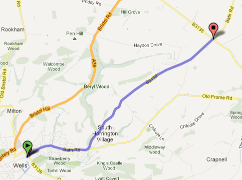
This route is the B3139 which goes north west out of Wells - worth mentioning as the A39 Bristol Hill route might be the way many of us would choose to use to get from Wells to Bath...

Start: Near Wells Cathedral at GR553459       Finish: Whitnell Corner cross roads  GR597487
Height Gain: 180m   Horizontal Distance: 5.6km
Average gradient: 3.2% (but see comments below)     Category: Low Cat 3

This suddenly became route 25. After discovering that Stancombe Lane was unsuitable for inclusion in the project, I needed a new target. A study of the map showed that, after the removal of the easting 57 limit, this is the one other climb which fulfils the new rules, everything else with a suitable road quality is still going up when it leaves the map.


Starting out from central Wells, the road rises gently through delightful old houses, colourful in the sunshine as I went past. The first km or so is pretty easy going, uphill, but only the prelude. The climb proper starts after a brief dip at the junction with Old Frome Road where our road swings up and left ignoring that way across to East Horrington. A 'countryfied' feel now surrounds the road as it steepens up towards the village of South Horrington. It's the next 2.5km that give some meat to this climb, averaging 5.6% as the B road steadily hauls it's way up Horrington Hill. As the cross section shows, there's a steady climb with little significant change of angle apart from a brief steepening after the cross roads with the lane joining East and West Horrington. The vistas are generally open, so you can get a feel for the challenge from relatively early. If you've been doing the others of this set then you know this won't stop you - it just helps you pace yourself.


Once you're past the cross roads there's a steady pull to the col between Horrington Hill and Windwhistle (well named today) where the road eases back, still climbing but easygoing through the high Mendip sheep fields, until the summit is reached about 400m before the Whitnell Corner cross roads. The last km hardly counts as climbing - only a 10m rise throughout.


Summary: Pleasant. Not hard. 

Stancombe Lane - no thanks!

Stancombe Lane was supposed to be the big finale. I was suspicious it might be thin - I knew it would be steep. This morning I went to investigate. The road surface is very poor (two parallel tracks with holes through one of the steep sections) and the road itself is very thin. This is not a recommendable route. Westfield Lane was a good road climb taking on a very similar challenge, there just isn't a reason why you'd risk getting mown down be car whilst taking this alternative. It is no longer on the list,
DP

Thursday, 23 August 2012

East Harptree, High Street and Middle Street

Success. At the fourth attempt. In the previous 3 I never even got on the hill. 1st time we missed the turn onto High Street, 2nd and 3rd time it threw it down with rain before I'd got out of the car. Keeping going when it's raining is fair enough; starting out in a thunder storm is something else entirely...

Start: At the junction where High Street leaves the B3114 GR569563
Finish: By the radio mast at GR550536
Height Gain:   191m     Horizontal Distance:   3.25km
Average Gradient: 6%  Category:  3

I had to take this in a short afternoon ride so I started from Burrington Combe car park; as good a place as any though all the roads into West Harptree make for pleasant cycling. Here you turn onto the B3114 to East Harptree, the climb starts at the junction about a kilometre along the road.


A sequence of easy steps leads to a ramp up into East Harptree, steep enough that the local non-cyclists will be impressed (it seems) that you can cycle up their hill, but not actually steep enough to hurt. The crossroads with Whitecross Road isn't straight, go left then right to achieve what looks like straight over on the map.


As the contour map shows, this remains easy territory but the pull up through the farmland suddenly gets a whole lot harder from shortly after the next but one junction; the slope altering from easy to 15%. Fight your way up to the sweeping left hander for a chance to rest the legs and regain a few gears before the right hand bend at Pit Farm brings the final challenge; the road steepening again briefly but this is only an issue if you're hurting from what you've already done. As I pushed my way over the top I had cramp beginning in both legs.


As the cross section shows, this climb hits you hard and hits you late. The sections from 1.5 to 2km and 2.5 to 3km are tough going, but doable. You finally peak at 294m, just about the highest point you can get to on a road in these parts and over 200m above East Harptree where you started from (the last 20m of ascent just hardly counts as climbing so I haven't included that part of the route in the stats). Workmen were resurfacing the B3134 back down to Burrington Combe - gravel everywhere. Should be OK again soon though, and descending Burrington has to be one of God's gifts to cyclists - though I recommend against hitting the top cattle grid at 35mph. Ow!

Summary: Well worth doing, just for the joy of completing a big climb (by Mendip standards) on decent road. Could easily be included in a route from Bristol down towards Wells, the obvious route being to drop down Old Bristol Hill - now there's a descent.
DP

Did this again (3rd time in 2017 so far - and it's only March!!!) this weekend. The steep bit in the middle is still a tough pull but after that 5 years of leg and lung development have certainly made a difference. Descended Broad Road and Westfield Road into Rodney Stoke - now that is a brilliant descent - under two minutes from the top of the Mendips to the houses in the valley. Weeeeee!
DP