Sunday 7 October 2012

Litton Combe and Torhole Bottom

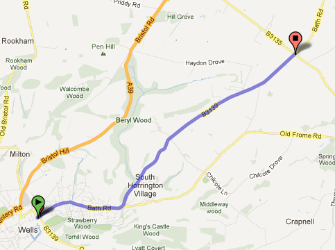
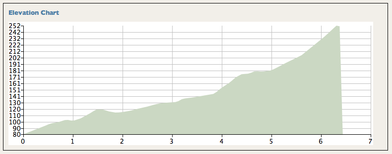
Start: On the B3114 at East Harptree
Finish: On the B3135 approaching the X-roads with Old Bristol Road
Height gain: 200m
Horizontal Distance: 8.5km
Average Gradient: 2.4%
Category: 3

I guess I didn't see this one when composing the original list of 25 as it lies partly east of the 570 easting that I was using as a boundary - but this is some climb. Granted my comments are made from hitting it 25 miles in - but not all climbs come at the start of routes.


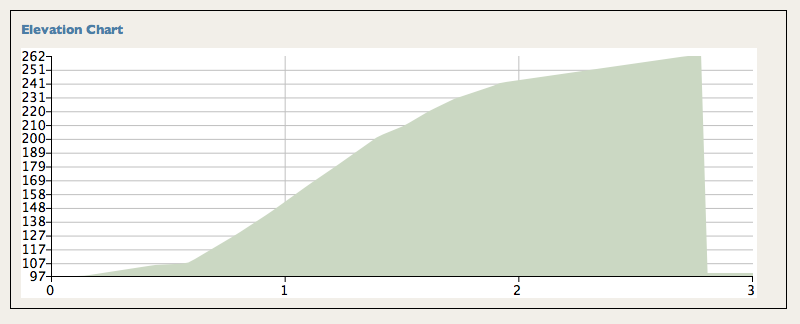
I've raved about the climb up Litton Combe before, but then commented how the route to Green Ore cross roads was ordinary and busy with traffic. This is a way better route. Having completed that steady  haul up the beautiful valley from East Harptree up to Chewton Mendip, you turn right onto the A39 but only do about a km of it before turning right onto Cheddar Road (which becomes Torhole Bottom as it progresses). Immediately you're back into the trees, on a quiet road with a great surface. Although this is a minor road it's wide enough that the traffic can pass you without threatening to turn you into road kill (apart from careless Range Rover drivers it would appear). The pull up is punctuated by a couple of steepish steps (see summary below) before the junction with the B road brings you almost to the top. Turn right towards Cheddar and, one more climb later, you're on the top of the longest climb in the area - yes, this is longer than Cheddar Gorge.


Rating: Clearly this has to get an (almost) excellent. Not only is it the longest climb hereabouts but it has all that wonderful scenerary. The only downsides are the brief stretch on the A39 and the fact that it involves three right turns. At least waiting for any traffic to pass doesn't count as taking a rest!
DP

Sunday 26 August 2012

Bath Road, Wells

This route is the B3139 which goes north west out of Wells - worth mentioning as the A39 Bristol Hill route might be the way many of us would choose to use to get from Wells to Bath...

Start: Near Wells Cathedral at GR553459       Finish: Whitnell Corner cross roads  GR597487
Height Gain: 180m   Horizontal Distance: 5.6km
Average gradient: 3.2% (but see comments below)     Category: Low Cat 3

This suddenly became route 25. After discovering that Stancombe Lane was unsuitable for inclusion in the project, I needed a new target. A study of the map showed that, after the removal of the easting 57 limit, this is the one other climb which fulfils the new rules, everything else with a suitable road quality is still going up when it leaves the map.


Starting out from central Wells, the road rises gently through delightful old houses, colourful in the sunshine as I went past. The first km or so is pretty easy going, uphill, but only the prelude. The climb proper starts after a brief dip at the junction with Old Frome Road where our road swings up and left ignoring that way across to East Horrington. A 'countryfied' feel now surrounds the road as it steepens up towards the village of South Horrington. It's the next 2.5km that give some meat to this climb, averaging 5.6% as the B road steadily hauls it's way up Horrington Hill. As the cross section shows, there's a steady climb with little significant change of angle apart from a brief steepening after the cross roads with the lane joining East and West Horrington. The vistas are generally open, so you can get a feel for the challenge from relatively early. If you've been doing the others of this set then you know this won't stop you - it just helps you pace yourself.


Once you're past the cross roads there's a steady pull to the col between Horrington Hill and Windwhistle (well named today) where the road eases back, still climbing but easygoing through the high Mendip sheep fields, until the summit is reached about 400m before the Whitnell Corner cross roads. The last km hardly counts as climbing - only a 10m rise throughout.


Summary: Pleasant. Not hard. 

Stancombe Lane - no thanks!

Stancombe Lane was supposed to be the big finale. I was suspicious it might be thin - I knew it would be steep. This morning I went to investigate. The road surface is very poor (two parallel tracks with holes through one of the steep sections) and the road itself is very thin. This is not a recommendable route. Westfield Lane was a good road climb taking on a very similar challenge, there just isn't a reason why you'd risk getting mown down be car whilst taking this alternative. It is no longer on the list,
DP

Thursday 23 August 2012

East Harptree, High Street and Middle Street

Success. At the fourth attempt. In the previous 3 I never even got on the hill. 1st time we missed the turn onto High Street, 2nd and 3rd time it threw it down with rain before I'd got out of the car. Keeping going when it's raining is fair enough; starting out in a thunder storm is something else entirely...

Start: At the junction where High Street leaves the B3114 GR569563
Finish: By the radio mast at GR550536
Height Gain:   191m     Horizontal Distance:   3.25km
Average Gradient: 6%  Category:  3

I had to take this in a short afternoon ride so I started from Burrington Combe car park; as good a place as any though all the roads into West Harptree make for pleasant cycling. Here you turn onto the B3114 to East Harptree, the climb starts at the junction about a kilometre along the road.


A sequence of easy steps leads to a ramp up into East Harptree, steep enough that the local non-cyclists will be impressed (it seems) that you can cycle up their hill, but not actually steep enough to hurt. The crossroads with Whitecross Road isn't straight, go left then right to achieve what looks like straight over on the map.


As the contour map shows, this remains easy territory but the pull up through the farmland suddenly gets a whole lot harder from shortly after the next but one junction; the slope altering from easy to 15%. Fight your way up to the sweeping left hander for a chance to rest the legs and regain a few gears before the right hand bend at Pit Farm brings the final challenge; the road steepening again briefly but this is only an issue if you're hurting from what you've already done. As I pushed my way over the top I had cramp beginning in both legs.


As the cross section shows, this climb hits you hard and hits you late. The sections from 1.5 to 2km and 2.5 to 3km are tough going, but doable. You finally peak at 294m, just about the highest point you can get to on a road in these parts and over 200m above East Harptree where you started from (the last 20m of ascent just hardly counts as climbing so I haven't included that part of the route in the stats). Workmen were resurfacing the B3134 back down to Burrington Combe - gravel everywhere. Should be OK again soon though, and descending Burrington has to be one of God's gifts to cyclists - though I recommend against hitting the top cattle grid at 35mph. Ow!

Summary: Well worth doing, just for the joy of completing a big climb (by Mendip standards) on decent road. Could easily be included in a route from Bristol down towards Wells, the obvious route being to drop down Old Bristol Hill - now there's a descent.
DP

Did this again (3rd time in 2017 so far - and it's only March!!!) this weekend. The steep bit in the middle is still a tough pull but after that 5 years of leg and lung development have certainly made a difference. Descended Broad Road and Westfield Road into Rodney Stoke - now that is a brilliant descent - under two minutes from the top of the Mendips to the houses in the valley. Weeeeee!
DP

Wednesday 22 August 2012

Coley to Green Ore Crossroads (Litton Combe)

Starts: On B3114 GR583555            Finishes: On A39 GR585512
Height Gain: 163m               Horizontal Distance: 6.3km                 Category: 3 (on length)

I first did this hill by accident. The intention had been to go up Smitham Hill out of East Harptree but we missed the turn.


Starting in the pretty valley around Coley on a flowing road surface, the first 1.5km of this route gives a very gentle climb as far as the village of Litton. Now comes the route's highlight, the narrow valley of Litton Combe enclosing the road as you climb through open farmland and past pretty houses to Chewton Mendip, still on gently climbing road. The turn onto the A39 at Chewton Mendip reveals a wider road and more traffic. As the road gently bends it keeps showing you another section of hill, some of them a bit more aggressively steep, but the angle remains easily manageable, never worse than 10% and then only for fairly short sections.


You could argue that the absolute top round here is the other side of the Green Ore crossroads but, given the drop down, the small difference in height and the fact that many cyclists will want to turn right onto the road across the top of the Mendips, I've decided to set the finish at the top of the steep section (GR585512) where the 23m drop begins. At this point you're 251m above sea level, if you carry on to Pen Hill wireless mast you'll reach about 265.

Summary: Pretty in the lower reaches, steeper at the end. A brilliant descent.
DP

An adaptation to the plan...

When I started out on this I set up the list of climbs based on keeping everything west of easting 57 on the OS maps. There were reasons - but they have to go...

Given that New Road, Draycott is closed I went hunting for the last of the 25 climbs on the map. Initially I put in a route up Dundry Hill from the Bristol side but I was never satisfied that this was a good choice. The start off the A38 seemed rather arbitrary, the A38 climbs from Bristol up to this point. To do the whole climb would mean cycling up that - which is a horrid road for biking in the Bristol area. Further, if the route was to be started from Bristol then somehow that felt as though it was out of area. I went hunting again.

I found an interesting looking hill rising through Butcombe running more or less parallel to the route we did from Lye Hole. That set alarm bells ringing though as readers will remember that the lane in question was hardly fit for cycling. I went to investigate - the new route was at least as bad and I can't think you'd thank me for sending you up another thin lane with a poor surface. Cutting that out left me with a problem, no more suitable hills in the area that don't have the same 'really suitable for very thin mountain bikes attraction'. 

So rethink. If we allow the area to include the whole of the Weston-super-Mare OS map area (OS182) then the perfectly pleasant run up Littondale followed by the admittedly less pleasant completion up the A39 (nowhere near as horrid as the A38) comes into play. So that's my answer. All the climbs have to fulfil the following criteria: -
  • They need to start, finish and be wholly contained on the OS182 map.
  • They need to climb 100m plus.
  • They need to qualify for a Tour de France category.
  • They should not be on lanes which have degenerated to become mountain bike territory on the steep sections where control of the bike could be seriously affected in the presence of traffic.
Regular readers will remember that there have been two other climbs with thin, parallel track type sections being the route up Shipham Lane and Highfield Lane out of Compton Martin. The first route could be started avoiding the narrow section by leaving Winscombe village eastwards on the A371 (fine for cycling) and then turing left on the A38 a Sidcot lights. This would provide a route of just about height gain and length. The other route, Highfield Lane, is more of an issue and, frankly, I stand by the warnings I gave a the time and the comment that Harptree Hill is a much better route up the same challenge. Having said all that, the surface wasn't so bad that it provided a threat to the tyres - so it can stay. Just! As for Lye Hole; again - it never threatened the tyres in the way the roads around Butcombe would and everyone needs a little adventure from time to time...
DP

Saturday 18 August 2012

Ebbor Lane and Deerleap

Start:  On the A371 at Easton GR509477         Finish: GR523497
Height Gain:      230m        Horizontal Distance:       3.8km          Average Gradient: 6.05%
Category: 3

When I looked at the stats for this climb and realised it sat just about on top of the points for the Llanberis Pass which I did last weekend I went back and re-checked. I was right though, the height gain and length of this route are just about exactly the same as that famous test in North Wales. So, this was going to be fairly tough - or perhaps doing the Pass into a 20mph head wind had made it seem that extra bit difficult..?


I came in across the moor from Westhay car park - a rough section of road that I don't recommend, even though it does an excellent line in wildlife. As the map above shows, the climb starts with an easy section up out of Easton with the tough starting after the left turn onto Deerleap.


Perhaps it was that few days of Welsh training - the bottom 80m of ascent seemed to die very easily but I knew that I was in for that tough section. It means it. As the cross-section shows, there's a steep section just after the flat to the curve in the road, the OS map shows a single arrow on this part. My map analysis has one 150m section with a rise of 25m - neatly 1 in 6 (or 17% if you prefer) in this bit. It's not 'out-of-the-saddle' territory, but definitely takes effort.


Mind you, it's definitely worth it as the views down to the Somerset Levels are superb looking down to your left and, by the time you've cleared the woodland, that's quite a long way down. There's a false summit at the end of the wooded section but after a very short dip the road rises again up one last steepish rise and then a gradual incline to the summit where you can keep on cruising along the decent quality tarmac. Keep going for just over a km; there's a pub on the corner with the B road though, if you're going to do the excellent descent of Bristol Hill into Wells, it's probably best if you don't stop.

Summary: Thoroughly enjoyed this one - one of the better tests in the area. Thanks to the guy I met half way up who threatened to "kill that Mendip Road Bike Climbs bloke if I can catch him". I was tempted to comment that the catch wasn't about to be made - I was pedalling up the hill, he was stopped at the side. So - apologies to any of you who are trying to do all 25 with me.

DP

Saturday 21 July 2012

New Road, Draycott

NO GO - ROAD CLOSED


'The' challenge of the area is closed...


SOMERSET COUNTY COUNCIL DISTRICT OF MENDIP PARISH OF RODNEY STOKE Temporary Closure of New Road, Draycott
TAKE NOTICE that in pursuance of Section 14(1) of the Road Traffic Regulations Act 1984, as amended by the Road Traffic (Temporary Restrictions) Act 1991, the County Council of Somerset have made an Order PROHIBITING ALL TRAFFIC from proceeding along New Road, Draycott from 5 metres east of the junction with The Binnings to 65 metres east of the junction with Vicarage Lane a distance of 90 metres.
This order will enable Somerset Highways to carry out drainage works in this road.
The Order becomes effective on 02 July 2012 and will remain in force for eighteen months. The works are expected to last for 10 days excluding weekends. While the closure is in operation an alternative route will be signed as detailed below.


So everyone will have to wait. And get fit. And then get used to cycling with their underpants over their bike shorts...

What are we waiting for?


800m of 1 in 5.3 (that's 19% in new money) with a lead in and a lead out that total a climb of 217m in 2km. An average of just about 11% (1 in 9). In French terms this is hard to classify. Category 3 is 1km at 10% to 6km at 5%. This is both longer and steeper than the steep end of category 3 then. On the other hand, category 2 spreads from 5km at 8% to 15km at 4%. New Road isn't long enough to qualify for this, but then it is rather steeper than the 8% here. I reckon that this is the West Mendip area's only Cat 2 climb - well, Cat 2 and a half anyway!
Good luck. Enjoy the wait. Keep eating the spinach.
DP

Friday 20 July 2012

Westfield Road and Broad Road
GR486502 (Junction with the A371 in Rodney Stoke) to GR507507
Height Gain: 189m     Horizontal Distance: 2.1km    Category: 3

Having made short work of Harptree Hill yesterday I decided it was time to take on the area's biggest challenge - New Road, Draycott... I plotted a course to give some 'wind up' mileage round Weare and Cocklake and got my son along for a 'training ride' ahead of our trip to North Wales in a few weeks time. Mike flew up the lower section of New Road, up as far as the A371, I pulled up behind and there it was - the ROAD CLOSED sign. Thinking back, there have been road closed signs on the other approach to this for a while now. Is it shut permanently? Time for a new plan...
I'd considered Westfield Lane before we went out, but decided to take on the bigger challenge. It's only a km or so along the main road, so it made a natural alternative.


The climb starts straight off the A road. The first half km is easy enough, averaging 8%, with a lovely right hander at the bottom pulling up round Hill Farm, followed by some steady pedalling to a tiny lane going off right - "Which way?", says Mike. "Up - left". Unfortunately my pace maker proceeded to suffer 'sprinter's legs' soon after this leaving me to kick on up the first of the arrowed sections. This first one felt more 1 in 7 than 1 in 5 (the range of the single arrow on the map) and died relatively easily. The road surface remains good so the 'between steep bits' sections at about 9% angle are acceptable, if fairly taxing. The second arrowed section doesn't let you off so lightly - it's the section just before 2km on the cross section.


There's about 150m of 20% gradient here which, after what's gone before, is a reasonable challenge. I was taking it at only 5mph. It leads to a right hand bend. I knew that if the angle lessened around that bend then I'd won. I suspected that if it steepened I would be in trouble. It lessened. This is, effectively, the top, as the road lies back to that 11-12% gradient that it has over most of the climb so you can reclaim a gear or two and relax - or do as I did and wave arms about like Mark Cavendish winning on the tour earlier today. Talking of sprinters - Mike got up and then proceeded to take 89 seconds out of me descending Cheddar on the way back. Madman!

Summary: You've got to be rather creative to get this into a logical longer route. It can be done, but it will be a test of your map skills. So, is it worth going to do for the sake of it? Oh yes! Anything which gets the sprinters riding in zig-zags has got to be worth it... If New Road is to remain closed then this is the second steepest climb in the area, only Stancombe Lane which does 10% for 2km is steeper. That's one of the four I have left to do from the original 25. Look out for a post in the second half of August, I hope.
DP

Harptree Hill
GR 552568 (junction with A368) to GR 543552 (Gibbett's Brow)
Height Gain: 150m    Horizontal Distance: 2.2km    Category: 3

When I did the parallel route up Highfield Lane I said that I was hoping for a better surface on this one. It is. The road is considerably wider, a number of vehicles passed me while I was on the climb and none of them involved a dive into the hedge which would have been the only solution on the other route.


The base of the climb is easy to find, the road down from the A368 to Chew Valley Lake is clearly marked. It could be argued that you should start this climb from the road by the lake, but I'd been that way a few days previously so I decided that the road in from Blagdon was enough compensation. Purists - there's a car park by Chew Valley Lake, but be warned, you'll be climbing from the outset if you use it.
From the junction the pull starts fairly easily but once it kicks in it stays there - this hill does not let go until you reach the junction with Western Lane. There's a twisting section (on really wide road) past Beaconsfield Farm where by staying well left on the road you can keep to a reasonable gradient - I guess this is the bit that shows steepest on the cross-section, but in the main, this is a hill where you (I) adopt a pretty low gear and keep on pushing the pedals round, only your pain threshold will determine your pace. Once you're through those bends and the bit immediately above it, the angle eases back just


enough as you get in sight of the Wellsway Arms. You can't stop - you haven't finished the hill! You've  climbed 86m in the first 750m of the climb, that's an average of 1 in 8.7 (or 11.5%). The steepest section through the bends is about 1 in 6 according to the map and the cross-section above, that feels about right even though there is no arrow on the map. At least that excellent road surface makes progress only a measure of your leg strength and breathing! All that remains is to finish the hill - but you're past the steep part of this convex bank now so you can steadily wind that pace back up...

Summary: Rather better than Highfield Lane, which deals with the same challenge in effect. This route forms part of a logical north-south ride passing Chew Vally Lake and up on to the Mendips. Go do it!
DP

Sunday 15 July 2012

Lye Hole to Row of Ashes Farm
GR 501623 to 519634
Height Gain: 103m      Horizontal Distance: 2.5km    Category: 4

You might take this climb in as part of a west-east ride across the area where you are looking to avoid the built up nature of Bristol, and traffic in general, or possibly as a way of getting up to Bristol Airport from the south avoiding potential death by speeding drivers on the A38 up Red Hill. Whichever, this is the epitomy of a quiet road, or as it was when we did, uphill canoe track! The map shows the general location.


We'd arrived from Wrington via Long Lane so, once the A38 was crossed we'd to drop down to Lyehole Farm. In the dry this might be a rapid descent, in the wet it was technical - one to avoid losing the back wheel and or sliding into the hedge or an on-coming car. Fortunately there were no cars.


Sutton Lane is also very narrow. It shows the lack of wear up the middle caused by there being only room for one car - anywhere. There's a 1 in 9 section close to the bottom, straight so you can see what you're in for but the top of it, which threatens more steepness eases off. The next half a kilometre is fairly easy, though still narrow, before a further steep section just after another little road goes off right. This bit is about 1 in 8 but looks worse as you approach it - "Oh heck - there's a wall" being my son's response on seeing it - to be fair he was cycling without access to any back cog bigger than 16 teeth.


Once up this the work is more or less over. Turning left at the T-junction at the top of the steep stuff there's a further rise to Row of Ashes Farm, but nothing of significance.

Appraisal: Quieter than the A38, but definitely off the beaten path. The climb has enough challenge to make it worthwhile, though it's spread out enough that it's never going to 'get you'. All in all - classic Cat 4.
DP

Saturday 14 July 2012

Limeburn Hill 
Follows the B3114 from GR 561632 to 563660
Ascent: 149m      Horizontal Distance: 2.4km         Category: 3


Starting from the roundabout where the B3114 crosses the B3130 there's a short drop down to a bridge but from there the work begins. I passed some poor soul pushing his bike expensive bike within the first few hundred metres - to be fair I was on the smallest of my three chain rings. 5 or 600m in and the road eases though and a steady rhythm gets you through that middle section relatively easily but, turning north as you pass the junction with the road down to Chew Magna, the


rest of the real challenge comes into view. As the cross-section shows, there's a brief but serious pull through some pleasant open farmland before rounding the top bend at Elton Farm throws you back onto flattening terrain and allows easier breathing.

Overview: Pretty good hill this with a decent road surface - though unfortunately much of the surrounding tarmac if pretty rough. Come on BANES - do some re-surfacing!

Monday 7 May 2012

Winscombe to Trott's Corner

I had a debate as to whether to include this one. With an average gradient of only 3.6%, it only just gets into the category of 'hill' at all but, with a length of over 5.5km it certainly goes uphill for a decent distance. So - included it is. And having included it we have to acknowledge that it would then be a category 3 climb on the numbers alone - but given the low gradient and the breaks in the middle, I can't find it within myself to give it, more than 4.

Start: GR 528583 on Shipham Lane, Winscombe      Finish: GR 463564 between Shipham and Charterhouse.
Height Gain: 200m         Horizontal Distance: 5.6km          Average gradient: 3.6%      Cat: 4


Starting eastward along the leafy lowland that is Shipham Lane, one quickly leaves the small estate and outlying cottages behind as you meet the base of the hill. The road isn't great quality; it's only single lane and quite narrow even by that standard. The surface is OK though - though a couple of winters will rapidly see to that. This narrow lane doesn't persist though as it meets the A38 - cross carefully.
Once over the A38 onto Broadway, the road is wider with a good surface. It continues its gentle climb past a selection of 'can I live here please' houses up to the village of Shipham where, again, the route is broken by a junction. This second cross roads has a tempting looking hill going straight over - but that's not our route. Turn right along a flattish section past Shipham school before hitting the first of the steep pulls as you reach Cuck Hill (the excellent road surface of which makes for a fun, fast descent if you're going the other way). Once up Cuck Hill you have to lose some height, about 10m, but don't go too fast down here as you need to turn left onto Longbottom at the base of the drop.
So that was the first half. Now you have a wide lane with a decent surface forging its way along the rising valley floor. Fields slope down to you from either side - just neatly channeling the wind if it happens to be from the east (which it was when I did it!). And then you realise that you're running out of valley. The road takes a sharp right turn to escape up the side. The road sign at the top of this coming the other way says 16% - which seems about right. It's about 250m up this steep section before you arrive on the easier section at the top, out onto typical high Mendip terrain of wild looking fields, sheep and wind-blown trees. All that remains is half a kilometre of easy climbing. By the time you get to the actual top your legs will be rested for a quick sprint..!


Rating: Worth deliberately including in a ride going west-east into the Mendips. Easier than Burrington Combe or Cheddar Gorge - puts you on top of the Mendips in the area that those climbs emerge.
DP

Wednesday 11 April 2012

Highfield Lane, Compton Martin

Start: GR 544571    Finish: 535555
Height Gain: 157m      Horizontal Distance: 2.8km    
Category: 3 (on height gain but not length - given 3 as the road surface is poor).

Confucius he say; "Man who take on hill with little warm up suffers for rest of day". Well OK, Confucius pre-dated the road bike by about 3000 years. The wise words remain true...

Starting from the parish hall at Ubley may provide an excellent base and a pretty secure place to leave the car, but it's too close. There's also the little point that Ubley sits on a hill below the A368 so you get 50m of climbing straight out of the village. I suggest you start from somewhere else - either take the hill as part of a longer run or start from the car park at the bottom of Burrington Combe to give a run in. But what of the route itself..?


You start as you pass Compton Martin Post Office, pedalling east on the A368. The section along the A road is easy, a bit of a bank to get you in the mood round a sweeping left-hander (don't be tempted to take the right turn here, it's one too soon and a dead end). Taking the second right you'll immediately notice the broken road surface - get used to it, it only gets worse - and that the hill proper has started. The first 800m averages 1 in 8.5 (12%) with the bendy sections seeming a bit more than that. This part of the  road is also especially poor so I kept needing to change which of the two strips of cleanish tarmac I was using - this is OK as the middle is only mossy, not grassed! One or two of the bends also respond to an active choice to dodge some of the steeper inside banks.
Once the road finds the little valley in the side of the hill it falls back a bit, the next 500m is only 1 in 13.5 (7.3%), but it still felt tough to me after the steeper lower section, Ubley village and no sensible warm up. I rather think it might have felt fairly tough anyway. This continues up to a straightening of the road and the end of the hard part. The hill continues for about a further kilometre but it's easy cruising now, up but it hardly counts.


Rating: Tough but OK. The body of the hill is only just over a km long so definitely not worth a specific trip to do, but reasonable to include as a hard challenge in a longer route. I wouldn't recommend a descent of this, too steep for the channels of tarmac available. Given the proximity of the B road route up Harptree Hill, which takes on a very similar challenge, I suspect that Highfield Lane will see little traffic apart from hill collectors. Look out for the Harptree Hill description when I do that one.

DP

Thursday 5 April 2012

Climb Categories

Firstly - thanks to Phil Price for the first set of information on how to categorise climbs - see link to his blog below.
http://www.triathlonphil.com/category-climbs-in-cycling-explained/

I haven't made any attempt up till now to categorise the climbs on the list  - it hadn't occurred to me that they might count in those terms. It would appear they do though so, from now on, I'll be having a go at categorising them as I do them. For what it's worth, using Phil Price's rules, I offer the following categories for the routes I've done so far...

Category 5
Winscombe Hill
Brockley Combe
A38 over Shute Shelve

Category 4
A38 Cowslip Green to Bristol Airport
Bleadon Hill from Bleadon Post Office
Bleadon Hill from Elborough 
Cheddar Gorge (it may be a 3 but I don't see it as having a sufficient average gradient and if you take the steep enough bit it isn't long enough - was given 3 in the Tour of Britain because it was placed at the end of a stage).
Shipham Road, Cheddar (tough end of 4)
Cleeve Hill Road, Cleeve
Dundry Lane, Winford to Dundry
Wrington Hill (!)
From Wrington via Long Lane and Redhill to Bristol Airport Perimeter Road (Cat 3 on height gain and surface  although the average angle is too low so given 4 over all).
Shipham Lane, Winscombe to Trotts Corner (though the numbers on this say cat 3 - see my comments).

Category 3
Blagdon Hill (from Rickford to Swymmer's Farm)
Cheston Combe from Backwell
Bristol Hill, Wells
Old Bristol Hill, Wells
Burrington Combe - numerically yes, but really?
Highfield Lane, Compton Martin

On the other hand, you could decide to use what are, apparently, the Tour de France criteria for grading the climbs. There still has to be allowance for where in a ride the climb comes, but the rules are as follows: -
Category 1: Anything between an 8km hill @ 8% and a 20km hill at 5%
Category 2: 5km at 8% to 15km at 4%
Category 3: 1km @ 10% to 6km @ 5%
Category 4: 2km @ 5% to 5km @ 2% - this fits neatly with my rule of not allowing any hill with less than 100m of climbing into the 'list'.

Using these Tour de France criteria, the categories would be as follows...

Category 3
Cheston Combe, Backwell
Bleadon Hill from Elborough
Blagdon (Two Trees)
Highfield Lane, Compton Martin
Harptree Hill, Compton Martin
Smitham Hill, East Harptree
Bristol Hill, Wells
Ebbor Lane and Deerleap, Easton
Stancombe Lane, Westbury-sub-Mendip
Westfield Lane, Rodney Stoke
West Mendip Way, Draycott
Old Bristol Road, Wells
Cheddar Gorge
Shipham Road, Cheddar
Cleeve Hill Road, Cleeve
Wrington Hill
Limeburn Hill
Winford - Dundry (Dundry Lane)

Category 4
Brockley Combe
Winscombe to Trotts Corner
A38 Cowslip Green to Bristol Airport
Bleadon Hill from Bleadon Bridge
Burrington Combe
Wrington - Long Lane, Redhill - Bristol Airport


No Category awarded
A38 Shute Shelve
Winscombe Hill
Interesting - nothing I've chosen to include on the actual list is less than category 4.

It would appear that the TdF categories bring far more into category 3. I would suggest that this is a function of the distances and exertion involved in completing the TdF and so, on the whole, I think Phil price's system is probably better for grading our Mendip hills.
Comments gladly accepted - please let me know what you think.

DP

Tuesday 3 April 2012

Cheston Combe from Backwell Cross

Start: GR 487686     Finish: GR503665
Height Gain: 167m    Horizontal Distance: 3.4km

So there I was, up Wrington Hill and still feeling fresh. I had intended just a short run back via Congresbury but now that didn't seem right. Well; I'd had a quick glance at Cheston Combe on the map this morning, didn't look to bad, go and do that...


Starting out from Backwell, dodging the parked cars, the bus and the recycling lorry, this seemed like the easy pull I thought I'd seen on the map. At the 'Y' junction I couldn't remember which way to go but chose left as it looked like the major road.  A passing pedestrian assured me that yes, this was the way up to the airport, I just had to turn right at the church. "Bit steep", she said - but I only worked that out later, I was too busy enjoying my sudden emergence from new Backwell into this gorgeous old-world village on a hill.
So, right at the church, steepish but OK, right at the bend onto a slight downhill that meets the other road I could have taken at the Y junction and then hard left. By the standards of what I've done so far, the road just rears round that corner. Battling for every pedal turn I came to realise that not all hills are meant to be climbed on a bike with a 39 tooth small chain drive. Breathing like a man back from 5 minutes under water I pushed on - but then the road steepened just a bit more and I had to accept that I needed a break. But I was not going to push the bike.


BikeRouteToaster shows the relevant section as about 1:5.5 but a detailed analysis of the OS1:25000 map shows that this 50m section of road climbs 15m, that's 1:3.3! I don't know, I'm just not used to anything that steep. I do know that it was hard to push off and get going again and that I couldn't relax sufficiently to get my left foot clipped for about another 2 or 300m.
What remains is neatly summarised by the cross section, banks and a couple of flats. The last pull let me know it was there, but I suspect that was simply because of the 3km before it. What remained for me was a problem. It wasn't that I couldn't do the hill in one go, it was that I couldn't do the hill in one go on that bike. Time for a change! Everything I've described on the blog so far has been done on the Barracuda RS100  that I bought last year. I didn't expect to use it for much more than back and forwards to work, but this bike riding game is addictive. This afternoon I took advantage of the 'Cycle to Work' and set up the order which will in due course, put me in possession of a Scott Speedster S40 Triple. No excuses when that arrives!

Rating: Outstanding. Pretty (once you're out of the new bit of Backwell), steep, hard, long enough to call a climb and an excellent road surface for the standard of road. Go do it. If you can do it in one go on a 39 tooth chain drive I don't want to know!

The Return: October 7th 2012. Re-doing this, all in one go, became the final challenge of the 25. This morning I went back, repeating the run in over Wrington to finish the job. I'd got the beginnings of a cold so Wrington was tougher than normal - didn't bode well for Cheston Combe. But it went. That middle section is still tough going but what a difference a bike makes! Using that 30 tooth chain ring on the Scott Speedster changed impossibility into straightforwardly tough. I think I even managed to keep the top cog on the back 'spare'. I stand by the rating, this is one of the best climbs in the area.

DP

Wrington Hill

Start: GR 473626       Finish: GR 475640
Height Gain: 133m     Horizontal Distance: 2.1km


I have to grant that I've been looking forward to this climb with some trepidation. Having first met it after doing Cleeve Hill Road, and having been terrified for my son at the pace he came down it, I saw this as a serious challenge. It may be short, but it does do steep.


The first section along School Road up to the cross roads is easy enough, the left turn you need to make at them provides a very short flat and then turn right into the meat of Wrington Hill itself. Analysis of BikeRoteToaster shows that this first section is 1:6.5, believable as it's steep but well in the do-able range (and this on a 39 tooth chain drive - see later blog) but there's only 225m of it so you just push on through. There follows an easier section, still about 1:9 but easy compared with that bottom section, before the hard left bend at the top. I found I had to go onto the wrong side of the road here, the gradient on the inside of the bend is just too steep, but the outside is OK and you can see that there are no cars coming down! There follows a gradual rise for a bit more than a further km but you've done the hard bit - a 100m climb in 1km. Wrington Hill is conquered - 3 months to be concerned by it and under 10 minutes to get up.

Rating: Too short to be rated very good - but hard enough to give a feeling of victory when you vanquish it. The drop down Cleeve Hill Road needs treating with care as the road is rough and a bit loose.

DP

Sunday 1 April 2012

Old Bristol Road, Wells

Start: GR553487     Climb: 201m     Horizontal Distance: 3.5km

Oh yez! Oh yez! This is a climb to write home about. The average climb gradient of 1 in 17 doesn't sound too bad, but bear in mind that there is a 1/2 km break in the middle of this so it's actually 1 in 15, and that's where the hard work kicks in!

Starting out from Wells you follow the A39 until a road name sign on the left indicates that it's time to turn left. You've already been going uphill, though not savagely, the left turn steepens the gradient and makes the right turn that follows almost immediately a harder task. The road is narrow, but well surfaced with surroundings of trees and then fields - not that you get to notice this much!
I'd had my eye on this hill for a while having met it when visiting a rather excellent garden at a house towards the base a couple of years ago. I remembered having to use the gears on the car quite a bit for getting up it - I remembered well!
So what's involved..?
As you can see from the cross-section, the first km has a steady pull, doable but work. Then comes a significant steepening but this hard section doesn't last - there's a slight downhill for a brief rest. Then the real work starts. The next 2km offers no respite as the road climbs steadily and sufficiently steeply to hurt. The cross section appears to show a constant gradient but a closer look at the OS map reveals the reality; there is an increase in gradient for the last 450m. There's a hard short section at the end of the long straight, you see it from well off and it looks serious. What you see is what you get though, the gradient isn't maintained as the road takes the slight left bend so you can relax for a 100m or so. And then the real test. You see it as one long straight, you've done the bends that keep you guessing - now it's there before you, the climb to the summit. It's 60m up in 400m horizontal. Head down, keep pushing, keep going.
You may gather I found this one tough. Most of it is steady grind, but a the harder end. It's that constant flow of effort that gives getting up Old Bristol Road such a feeling of achievement - the hard bits have all come after fairly hard bits, there is no steady 1 in 20 on here.
Rating: Come and do it - it's better than Cheddar. Different to the parallel road on the A39 Bristol Road. In a sense it takes on the same challenge - but this is steeper and more intense.

Better? I'd say so, a sharper pull and far less traffic - but Bristol Hill is a good route too.
DP

Sunday 26 February 2012

Brockley Combe to Bristol Airport

Start: A370 GR: 473668    Finish: Bristol Airport Perimeter Road GR: 496648
Horizontal Distance: 5.9km       Height Gain: 155m

I would guess that most readers will have 'done' Brockley Combe a some stage. Perhaps not this version though. Most will have started from the crossroads on the A370, proceeded up Brockley Combe and Downside Road and finished on the A38 beneath the the airport. And there's the point. There is a variation that finishes above it. Watch out for the little road on your right once you've passed the 16th tee of Tall Pines golf club, it's called Cooks Bridle Path, but in fact it's a perfectly passable road. Follow this and it will take you up to the airport, round the perimeter road then to a sharp right angle bend where the road turns south and you've arrived at the summit.


As you may well know, the section up Brockley Combe and Downside Road isn't too demanding. For sure there's a steady climb but the angle is simple enough. The sting in this route comes on the Cooks Bridle Path section; there's a reasonable bank up past Tall Pines golf club which leads on to another onto the airport perimeter road. The perimeter road itself is perfectly pleasant (and about level) before a dip round past the end of the runway leads on to two final climbs, one pulling up from the right angle bend that takes you back east after passing the runway and and another up to the summit past all the people watching the aeroplanes take off... Why? I guess they're wondering why we're cycling up the hill. But only we get to sail off down to Wrington.


Summary: Perfectly pleasant. Not overly demanding but fairly long with a sting at the end. 

Monday 13 February 2012

Winford to Dundry via Dundry Lane

Start: In the centre of Winford GR540652    Finish: In Dundry village GR553665
Horizontal distance: 2.4km    Height gain: 120m

The narrow lane up to Dundry is clearly sign-posted from the 6 way junction in the middle of Winford so you can press on knowing that this narrow little road really is the right way!

There seemed to me to be a bit of a climb (brief) near the bottom which doesn't show up on the cross section profile, but in the main the first kilometre out of Winford is pretty easy. Enjoy the tranquility of open farmland - it's hard to believe that you're only a couple of miles from the edge of Bristol. I was visited by a Buzzard. Actually that's not quite true, the Buzzard swept across the front of me and visited something in the field at the side of the road - Buzzard lunch.
Having not been selected from the menu I then got to meet the most courteous of farmers. Seeing me coming up the hill he actually pulled his Land Rover right against (into) the hedge in order to let me get past. A farming cyclist?
If you've looked at this climb on the map you'll have seen the gradient arrow. A house on the right marks the start of the serious ascent which, whilst only averaging 1:10 has a couple of far steeper sections with a 100m or so of something between 1:5 and 1:6 (judged by what I had to do to get up it - i.e. lowest gear and up out of the saddle for a quick burst.
When you can see the radio mast on your left you're up bar for the convex bit at the top. It was short, it was steep and it was so much more pleasant than the climb up to Bristol airport on the A38 that more or less immediately preceded it.


Rating: A really nice little climb. 

Cowslip Green to Bristol Airport

Start: On the A38 at Cowslip Green GR481616      
Finish: Northern Bristol Airport Roundabout GR513654
Horizontal Distance: 5.0km   Height Gain: 155m

The road surface on the A38, north from Churchill lights, is rough and jarring so in may ways slowing down for the hill itself comes as a blessing. As the road has been laid out with an overtaking lane almost all the way up the hill the ever present fast moving traffic isn't too much of an issue - though it does provide a collection of pretty noxious gases to breathe in as you go. Perhaps I was unwise to choose a Monday morning.
Crossing the bridge over the Congresbury Yeo you can see the scale of the hill in front of you. You can't see the road, but you can see the crest of the hill and it's flat up there with an airport on the top so that's where you're going. The first kilometre or so is easy enough, just a gentle grind, but a short steeper section near the right turn for Lye Hole (and the Butcombe brewery) lets you know this isn't going to die easily. This is a short section though and the road again settles into a more affable gradient for 200m or so before you start on the hill proper and settle in to gain 90m in the next kilometre. The gradient does remain pretty constant through this part so can you settle into a rhythm and work on up. Keep your concentration though as the biggest issue is avoiding getting flattened by a speeding vehicle (most were doing over the allowed 50mph this morning according to the speed camera - I wasn't!) as you pick a line that avoids the potholes in the road.
Once through the small village of Redhill the gradient eases back considerably leaving you to finish the pull to the mixed sounds of aircraft and passing traffic. I must say I wish I'd made a 'no busy A roads' rule when selecting the 25 routes! Still - it's an obvious local hill and one that I guess most local cyclists will have done at some point.
Rating: Would be a really nice climb if the surface were better and the traffic was removed from the road. I suggest taking it on about 2am just after someone gets round to re-surfacing it. In the meanwhile, I suggest the recently described route from Wrington to Redhill and then up the lane the other side of the airport as a far more peaceful and less dangerous alternative that runs broadly parallel to this one.
DP

Saturday 28 January 2012

Wrington to Bristol Airport GR497638

Start: Wrington centre (Branches Cross)        Finish: Winters Lane above Bristol Airport
Distance: 4.6km      Height Gain: 160m

A short sharp climb out of Wrington leads to a sharp right bend where the road heads east across the side of the hill. Although this road steadily climbs, in a sense the first climb is over and the second is yet to start. The eastward treck along Long Lane picks its way through a gorgeous selection of houses, farms and farmland - this is north Somerset countryside at its prettiest. Enjoy - the left turn at Redhill changes the picture to wilder, more upland, scene - but you'll be needing to keep a keen eye on the road as the surface leaves a great deal to be desired.
Immediately you make the left turn onto this section the road steepens, there's a straight stretch of steady climb and more follows with a delightful series of bends. A brief dip leads to a tricky right angle bend and then there's the final climb up to the airport. All that remains is to wonder why there are so many people watching the aeroplanes take off - while they wonder why we want to cycle up hills on bikes!


Rating: Enjoyable. An interesting route from Wrington to Brockley Combe where it would be possible to continue on along a range of interesting routes if you chose to make this part of a longer route.
DP

Sunday 22 January 2012

Blagdon Hill via Two Trees

Start: GR498594         Finish: GR503573
Distance: 2.7km          Height Gain: 195m


It seems to me that when the average gradient climb exceeds 1 in 15 then there is a substantially greater feel of hard work about it. This route definitely falls into that category. Starting on the A368 at the drive entrance of Combe Lodge, an arbitrary point as you've already climbed up to this from Rickford, one enters Blagdon village and completes the first 20m or so of the ascent by the point of taking the right turn onto the minor road by the pub. In truth, for safety on the bend, it is better to go round the bend on the A368, make a U turn using the pub car park, and then turn left. You'll probably already be in a low gear by the point you make this turn and the road rising in front offers no respite. 300m of 1 in 10 away from the junction are followed by news on a road sign that it's about to get steeper - I think it said 1 in 7 - but I found this section tough going. Up round a left bend, still no real respite, the road swings left again and now their is a brief lull as the gradient drops back. Then it starts again! The respite was no more than 150m; the right bend at its end brings the next haul.
Take the leftward option at the Y-junction (the Ellick Road route takes the one on the right) and continue the steady haul up the bank, steep at first, then dropping back to about 1 in 15. This section is comfortable, but you can see the break of slope ahead on the straight and from Blagdon farm there's a hard pull onto the top at a slight right bend with a big tree to use as an aim point - except it didn't seem to want to come any nearer. This top section only measures at 1 in 9 on the map, but the exertions involved in getting to it made it seem a lot steeper than that to me.
And then you're up. The sweeping roads on the top of the Mendips are there to welcome you, allow you to increase speed and give your legs and lungs a rest. For me a 'relax' down to Paywell Farm and then home over Charterhouse.


Rating: A stiff climb that never really lets go from the point you start in Blagdon Combe. Well worth doing, with a great feeling of success when you (I) got to the top - most of the lower angle road is at the bottom.

Footnote (19/9/12): First time I did this I was on the Barracuda. I had to stop for a rest! Given that, I didn't really feel I'd done the hill properly. Last weekend I went back. Ah, the difference that 8 months makes. Firstly, I now have the Scott which is just better. Second - I've done a few more miles since then; about 1200 as an estimate. Combine these two differences and the effect is enormous. From needing a rest first time up, on Sunday I managed it in reasonable comfort. The bend near the conference centre is still tough - I surprised a driver by cycling up the edge of the wrong side of the road round that, but the top is perfectly OK and I always knew I would get up - so much so that I completed the afternoon with an ascent of Shipham Road and then the A38 from Churchill and off up the B road to Shipham. There's no way I could have done that back in January. If it wasn't Tejvan Pottinger who came past me at the top of the A38 bank then, who ever you are, go compete with him in the Burrington hill climb!

Saturday 14 January 2012

Bristol Hill, Wells

Start: 550464       Finish: 570489
Length: 4.3km  Height Gain: 212m


There's an immediacy to this hill as it climbs out of Wells, 55m of ascent in the first 700m of road. So, settle in for the pull early - if your experience is anything like mine you're in a fairly low gear from the off. A patch of trees on your right, revealed by one of the many slight bends that characterise this hill, signs a brief respite and time to gain a gear or two back. The respite doesn't last, so you'll need that variation in gears available as you snake your way through the sequence of straights leading to bends. There's something about the landscape which keeps suggesting that the road will level out after the next bend, which it steadfastly refuses to do, there are at least seven of these straight sections, each time you see a few hundred metres more of the hill. The angle never rears up at you but the length and continuity of the climb take their toll (well, not on JT-L, but they did on me!).
There's a pleasant variety of countryside on this pull, starting from the town, through sections of woodland, through sections of open Mendip farmland - all very pleasant. A pity then that there are so many fossil fuel devourers sharing the tarmac. In due course that tarmac leads out of the top of Biddle Combe woods at a track leading up to the WT station on Pen Hill and you're just about up - unless you decide to take on the dead end track itself.


Rating: Well worth making a specific trip to do, the route was on last year's Tour of Britain after all! The length of the hill provides a significant challenge, unless you happen to be Jonathan Tiernan-Locke. There is too much traffic - look out for comments on Old Bristol Hill which effectively takes on the same challenge - still on my to do list.

Sunday 8 January 2012

Bleadon Hill from Bleadon (Bridge)

Start: 341570         Finish: 358578
Length: 3.0km      Height Gain: 127m

When I first looked at this one on the map, I thought the climb started from Bleadon Bridge, but in truth there is so little rise from their to the post office in Bleadon that it is reasonable to start from the junction with the road coming in from Loxton - which fitted our route better, so that's what we did...
Starting with a fight to get feet clipped into the pedals before the steep section starts, I missed the pretty houses that sit at the beginning of this climb. The bottom section gives a stern pull for about 300m before a sharp left bend leads to a brief respite. Then comes the sharp right hander to a view of what this hill is really about, a stiff climb (about 1 in 6) as the road climbs into the hamlet of Bleadon Hill. Another sharp left takes you into a narrower, possibly slightly steeper, section - but it's only about 200m before the road flattens enough to make the right turn onto the minor road that continues to the top of Bleadon Hill a comfortable task.
The top road still leaves you with a 40m climb and there are some short sharp pulls on it, notably the rise to Bleadon Hill Golf Club which gives the appearance of a small wall as you approach it! From here it's easier, a steady climb up the last kilometre to with excellent views of the sea on both sides.


Rating: Well worth the outing. You'll need a specific effort to include it - but I'd make the effort again.
DP

Friday 6 January 2012

Winscombe Hill

Start: GR 413568     Finish: GR 415563
Length: 900m     Height Gain: 50m

Whilst definitely not big enough to count in the West Mendip top 25, this is a worthwhile little hill. The approach along the lane from the Winscombe Triangle (GR 415576) is pleasant - a widish lane through housing with an affluent, oldy-worldy feel. Once you pass the lane back towards the playing fields the hill kicks in. There a gentle concavity to the slope, it gets steeper as you go higher! The stretch up to the church provides the feel of a hill that you're easily conquering, steep but not critically so, but the left bend in front of the church grounds brings a steeper rise into view for a pull of 100m or so at around 1 in 6. The narrow lane under the trees, past the odd remaining cottage just requires to be pedalled up, but it gives out all too quickly and you find yourself on the level ground and then shooting down to the car park for the walkers going over Winscombe Hill to Crook Peak.


Rating: Really nice - but too short. Well worth including in a run that involves going from Banwell towards Cross and Cheddar -  a much better route than the A38 over Shute Shelve.